Sense & Scale

A site to explore cultures, cities, and computing at varying senses and scales. Updated by Ar Ducao, with content from classes at NYU, MIT, CUNY and more.

Contact: see syllabi

  • Here’s a link to the live visualization. And good news: this tutorial involves no coding! Background More soon. For now, you can learn about MindRider helmet and data at their respective web sites. Getting Started Download QGIS and install (from QGIS) the QGIS2threejs plugin. Obtain this tutorial’s data, which includes these vector shapefiles:…

    Here’s a link to the live visualization. And good news: this tutorial involves no coding!

    Background

    More soon. For now, you can learn about MindRider helmet and data at their respective web sites.

    Getting Started

    1. Download QGIS and install (from QGIS) the QGIS2threejs plugin.
    2. Obtain this tutorial’s data, which includes these vector shapefiles:
      • a MindRider sample dataset (800 points)
      • Manhattan’s buildings south of 14th street
      • the polygon I drew to clip the original NYC building footprints to just this region. Rendering all the buildings for the entire city could crash your browser.
    3. In QGIS, add the MindRider data by navigating to Layer > AddLayer > Add Vector Layer. Add “MR_data_SampleSet.shp” from your tutorial data.
    4. NOTE: In your tutorial data folder, you’ll only be loading the shapefiles (.SHP extension). The other files (i.e. dbf, shx, etc) are supporting metadata for the shapefiles, so don’t remove them!
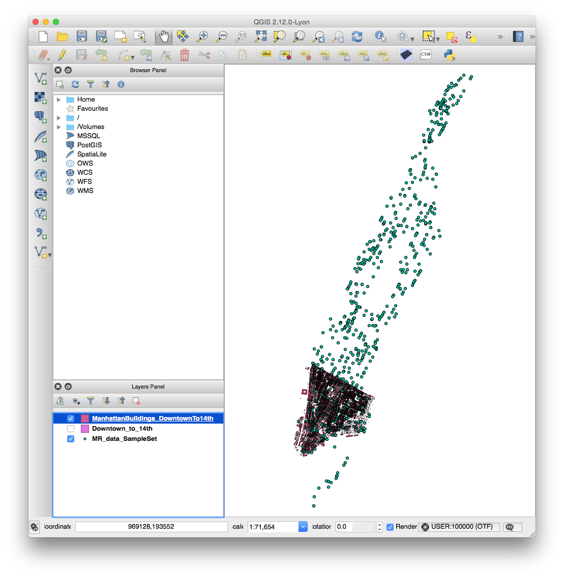
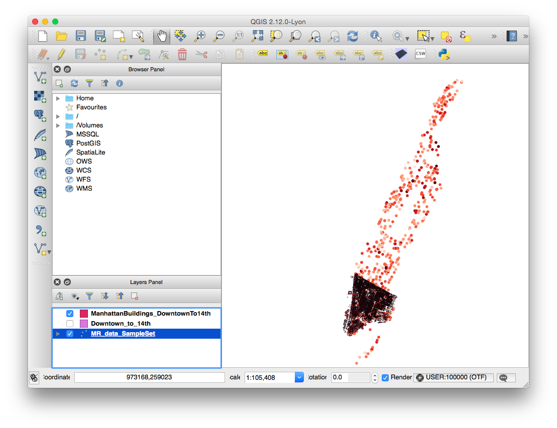
    5. Add the building by navigating to Layer > AddLayer > Add Vector Layer. Add “ManhattanBuildings_DowntownTo14th.shp” from your tutorial data. Your QGIS window should now look like this:
      Screen Shot 2015-11-05 at 3.13.59 PM
    6. NOTE: You can optionally add “Downtown_to_14th.shp” to your project to see what it looks like, but you won’t visualize it for the final render. If you’d like to crop another part of the building elevation data for your own purposes, see this link about creating polygons and this link about cropping shapefiles.
    7. NOTE: If you import the NYC Building Data directly from its source, you will need to re-project it. See this link for a note on the proper projection to use.

    Coloring the MindRider data

    In this section, we will color the MindRider data points varying levels of red based on the cyclist’s mental attention, from a range of 1-100.

    1. In the Layers Panel, right-click MR_data_SampleSet and choose “Properties“.
      Screen Shot 2015-11-05 at 4.39.30 PM
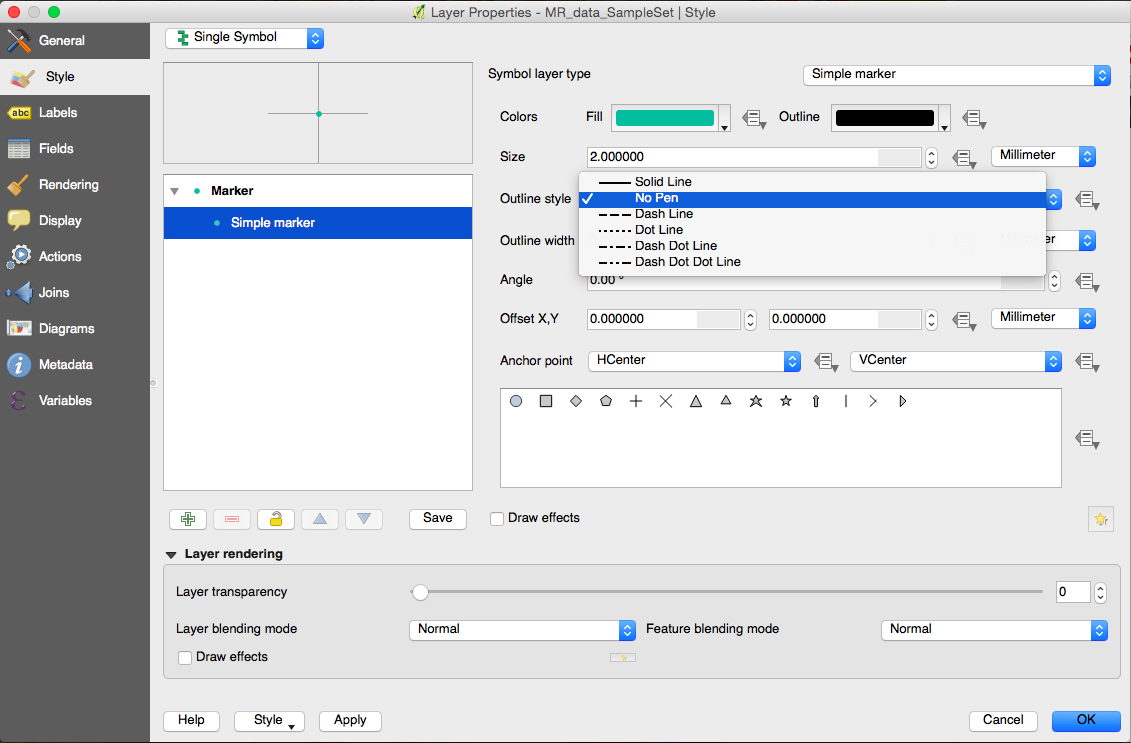
    2. By default, the Properties window will be in the Style tab, and your marker type will be a Simple Marker. Remove the black outline from the markers by choosing No Pen from the Outline Style menu.
      Screen Shot 2015-11-05 at 4.46.24 PM
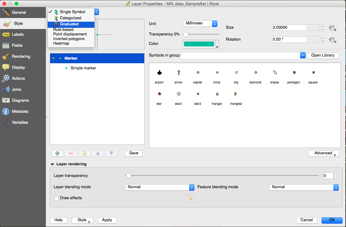
    3. Next, switch from “Single Symbol” to “Graduated Symbol” in the topmost menu.
      Screen Shot 2015-11-05 at 4.49.03 PM
    4.  Now change the following values:
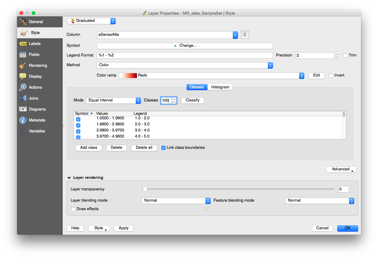
      • COLUMN: eSenseAtte
      • COLOR RAMP: Reds
      • Classes: 100
        Screen Shot 2015-11-05 at 4.55.35 PM
    5. Press OK, and the MindRider data should now be colored according to attention values.
      Screen Shot 2015-11-05 at 4.58.15 PM

    Coloring the NYC building data

    You don’t need to color the buildings according to height in order to extrude them with QGIS2threejs, but after an initial attempt without the color coding, I found it color to be a helpful aid in comprehending the visualization. I chose blue to contrast with the MindRider data, which is generally colored red-yellow-green.

    1. In the Layers Panel, right-click ManhattanBuildings_Downtown_to_14th and choose “Zoom to Layer.”
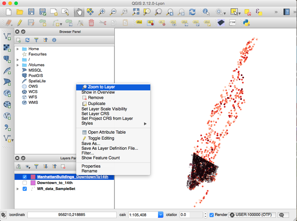
      Screen Shot 2015-11-05 at 5.04.42 PM
      Now you can see the layer more closely.
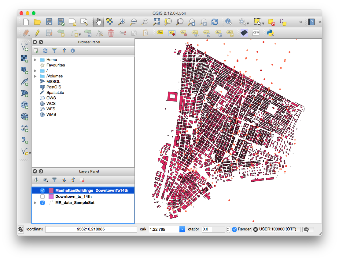
      Screen Shot 2015-11-05 at 5.05.01 PM
    2. Remove building footprint outlines using a similar method as used for the MindRider data:
      • In the Layers Panel, right-click ManhattanBuildings_Downtown_to_14th and choose “Properties“.
      • Remove the outline by choosing Simple Marker, then choose “No Pen” in the Border Style menu.
    3. Color the data a varying range by choosing Graduated in the top menu (just like you did with the MindRider data). Change these values:
      • Column: HEIGHT_ROO
      • Color Ramp: Blues
      • Mode: Natural Breaks (Jenks)
      • Classes: 10
      • Screen Shot 2015-11-05 at 5.15.32 PM
    4. Press OK and see that the building data is color-coded.
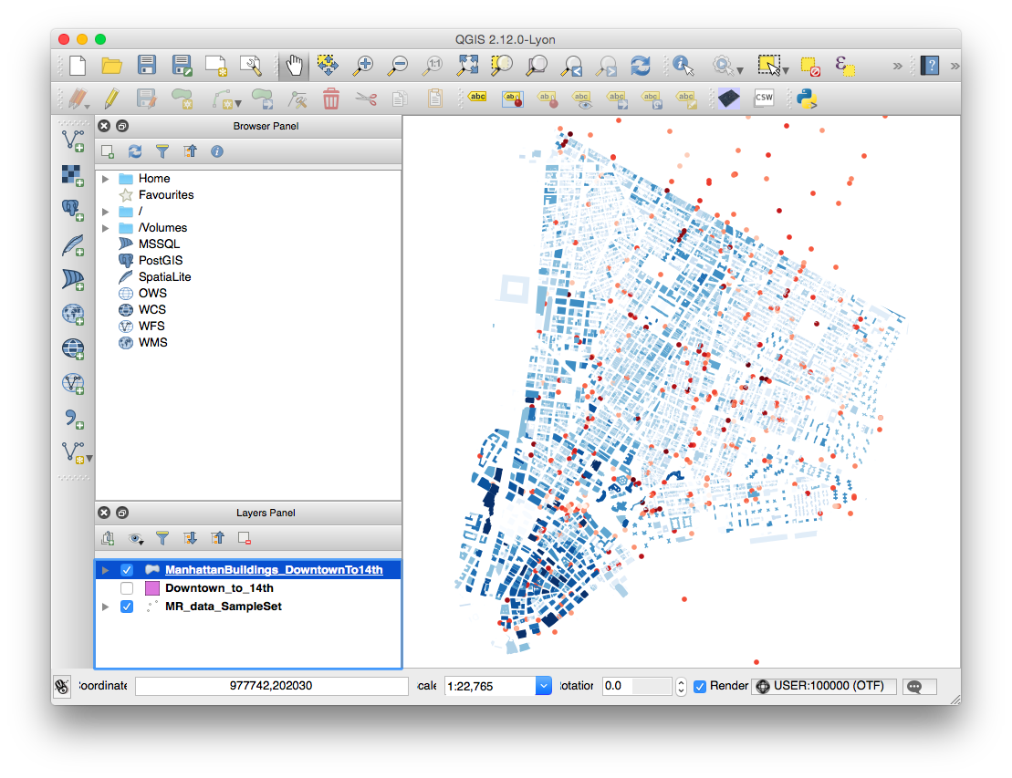
      Screen Shot 2015-11-05 at 5.17.07 PM

    Export (render) the data using QGIS2threejs

    Let’s try exporting this data to an HTML site.

    1. If you’ve installed QGIS2threejs, an icon for the plugin will show on the 2nd tier of tools in your window:
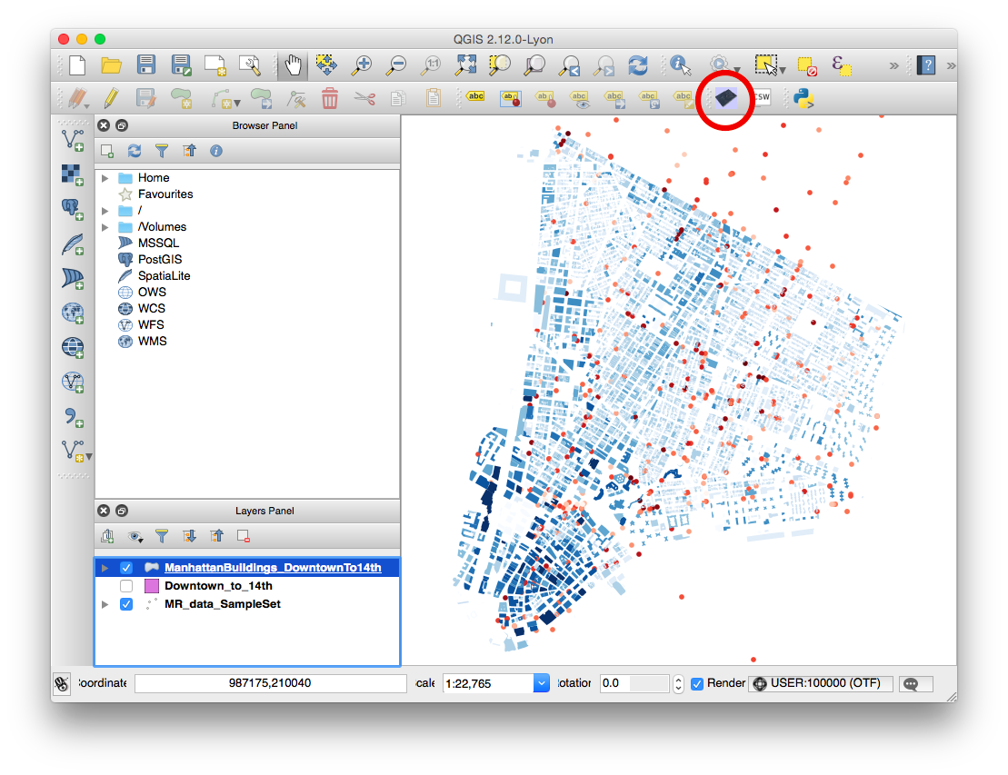
      Screen Shot 2015-11-05 at 5.21.16 PM
    2. NOTE: You will only choose the ManhattanBuildings for rendering via three.js. The MindRider data, since it’s visible in the QGIS project window, will be rasterized and displayed on a flat pane at the base of the extruded buildings. If you were to render the MindRider data as 3D objects, this would make your page take a LOT longer to load.
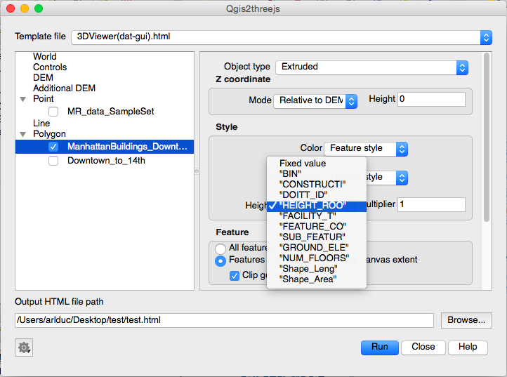
    3. In the QGIS2threejs dialog box, you only need to do two things.
      • check the box next to the ManhattanBuildings_Downtown_to_14th data set so that it will be rendered in WebGL.
      • specify Height as “HEIGHT_ROO” so that the buildings are extruded based on height.
      • Screen Shot 2015-11-05 at 5.24.27 PM
    4. Specify the output file name and filepath. I recommend that you create a new directory for your file, as several supporting files will be generated in addition to the HTML file.
    5. I called my file “test.html.” When I opened it in my browser, it looked pretty good!
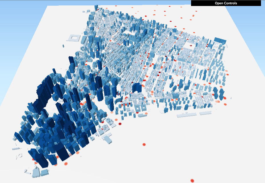
      Screen Shot 2015-11-05 at 5.33.31 PM

    Now for a Challenge!

    You’ll notice that the image at the top of this tutorial shows both green dots and red dots, which indicate MindRider “sweetspots” (areas of high relaxation) as well as “hotspots” (areas of high attention). You’ve already visualized the hotspots. Can you visualize the sweetspots as well, and make it so that the hotspots and sweetspots blend together?

    It’s pretty straightforward if you think about it. Here are the basic steps:

    1. Duplicate the MR_data_SampleSet layer. Call it something like MR_sweetspots. For clarity’s sake, re-name your original MR_data_SampleSet to MR_hotspots.
    2. Re-color the MR_sweetspots with a green gradient.
    3. In the same dialog box where you change the layer’s color, you can experiment with Layer Rendering:
      • Try changing the layer’s transparency to 70%.
      • Try changing the layer’s blend mode to Darken or Multiply.

    And see what happens! You can see my version of the sweetspots AND hotspots visualization here.

    + , ,
  • Made in the Machine: New cultural practices, critical analyses, and techniques in digital fabrication, making, and manufacturing Recent innovations in digital fabrication have made its technologies much more cheap, sophisticated, and accessible for people of many ages and experiences. In this class we will explore some of these innovations, the…

    Made in the Machine:

    New cultural practices, critical analyses, and techniques in digital fabrication, making, and manufacturing

    Recent innovations in digital fabrication have made its technologies much more cheap, sophisticated, and accessible for people of many ages and experiences. In this class we will explore some of these innovations, the techniques and affordances that they enable, and the future directions that they imply.

    This will be a project-based class, but as much emphasis will be put on cultural and critical analysis as on technical learning. Class sessions will involve case studies, guest speakers, site visits, and discussion of fabrication methodologies.

    Learning goals:

    1. Learn one or more new digital fabrication technique(s) to understand the experiential context of fabrication. Deliverable: fabricate a simple object.
    2. Examine and critique modes of machine production in a socio-historical setting. Deliverable: write a short research paper or piece of creative nonfiction.
    3. Combine goals 1 and 2 to comment on new and emerging trends in digital fabrication at multiple scales. Deliverable: To be discussed in class.

    Prerequisites:

    An interest in digital fabrication and its impact on the fabric of society. Basic experience with a fabrication technology is recommended, but not required. Examples include:

    • 3D printing
    • Digital cutting (laser, water, etc)
    • CNC milling
    • Digital wire bending
    • Computational sewing or knitting
    • Mass manufacturing
    + ,
  • Announcements http://www.datasociety.net/ Agenda 6:30-7:00 Class updates 7:00-7:30 Bex Hurwitz, Founder, Research Action Design 7:30-8:00 Timeline.js Exercise 8:00-8:10 Break 8:10-9:20 Finish Timelines, add Personas Assignment for Nov 5 No Class next week! Expand on your timeline exercise and post to your blog OR upload and discuss the persona design images that your classmate…

    Announcements

    Agenda

    6:30-7:00 Class updates
    7:00-7:30 Bex Hurwitz, Founder, Research Action Design
    7:30-8:00 Timeline.js Exercise
    8:00-8:10 Break
    8:10-9:20 Finish Timelines, add Personas

    Assignment for Nov 5

    No Class next week!

    • Expand on your timeline exercise and post to your blog
      OR upload and discuss the persona design images that your classmate designed for your midterm project.
    • (optional) Make any final modifications to your midterm. If you do this, let me know when you’ve finished so I can reissue your progress report. I will lock down midterm grades on Nov 5. If your grade is low, I will be in touch before then.
    +
  • Data is in this TimelineJS template.

    +
  • Presentation Order 6:30-6:35 Announcements 6:35-6:45 Sandra Song 6:48-6:58 Daniel Silber-Baker 7:01-7:11 Neill Chua 7:14-7:24 Sweta Mohapatra 7:27-7:37 Sam Tarakaijan 7:40-7:50 Hovsep Agop 7:50-8:10 BREAK. Please fill out this class evaluation. 8:00-8:10 Helen Carey / Sriya Sarkar 8:13-8:23 Gabe Weintraub 8:26-8:36 Marijke Jorritsma 8:39-8:49 Patrick Moraitis 9:02-9:12 Anneka Goss 9:12-9:20 Final Notes Announcements http://monoskop.org/Bauhaus Next Week’s Assignments Post all your…

    Presentation Order

    6:30-6:35 Announcements
    6:35-6:45 Sandra Song
    6:48-6:58 Daniel Silber-Baker
    7:01-7:11 Neill Chua
    7:14-7:24 Sweta Mohapatra
    7:27-7:37 Sam Tarakaijan
    7:40-7:50 Hovsep Agop
    7:50-8:10 BREAK. Please fill out this class evaluation.
    8:00-8:10 Helen Carey / Sriya Sarkar
    8:13-8:23 Gabe Weintraub
    8:26-8:36 Marijke Jorritsma
    8:39-8:49 Patrick Moraitis
    9:02-9:12 Anneka Goss
    9:12-9:20 Final Notes

    Announcements

    Next Week’s Assignments

    • Post all your midterm materials:
      • visualization
      • write-up
      • slides
      • link to data source
    • Ensure that your 5 blog posts (not including the midterm) are up.

    +
  • Announcements and Links Catherine D’Ignazio presentation Nat Geo: Data Visualization from Eye Candy to Efficiency NYU Libraries Data Services MIT Sloan Sports Analytics Conference NYC Media Lab Combine (incubator) Verizon Connected Futures Prototyping Challenge NYU Stern Conference on Big Data and Mobile Marketing New School Platform Coopertivism Internet and Democracy Conference…

    Announcements and Links

    Agenda

    • 6:30-7:30: Ekene Ijeoma lecture / Q&A
    • 7:30-8:00: Class updates
    • 8:00-8:10: Break
    • 8:10-8:55(ish): Kevin Miklasz lecture entitled “Function vs. aesthetics in data visualization: some case studies”
    • 8:55-9:20: Work time and feedback from guests

    Notes

    Next Week’s Assignments

    • Midterm, due next week. A full project brief is here. If it will help you prepare, I can write a walk-through of one of my previous visualization projects (which includes a write-up) that is about the same scope as a midterm or final, depending on your prior technical experience. You can see the project files for this vis, called “Networks in Equity and Sustainability,” at Github.
    • Make sure your 5 blog posts (not including the midterm) are up by next week. If you owe extra credit for a missed class(es), be sure to expand one of your assignments accordingly. Let me know if you have any questions about this.
    +
  • Announcements and Links Data Visualization from Eye Candy to Efficiency Agenda 6:30-7:15: Updates (including visualization assignments) 7:15-8:15: Catherine D’Ignazio lecture / Q&A 8:15-8:25: Break 8:25-9:15: Remote sensing (satellite data) lecture / Q&A. Guest co-speaker: Ilias Koen. 9:15-9:20: Final notes and comments Notes Remote sensing: Spectral, Temporal, Spatial Working with Landsat Data (2006)…

    Announcements and Links

    Agenda

    • 6:30-7:15: Updates (including visualization assignments)
    • 7:15-8:15: Catherine D’Ignazio lecture / Q&A
    • 8:15-8:25: Break
    • 8:25-9:15: Remote sensing (satellite data) lecture / Q&A.
      Guest co-speaker: Ilias Koen.
    • 9:15-9:20: Final notes and comments

    Notes


    Next Week’s Assignments

    • Blog post (due next week): Complete another brief visualization exercise. It can, but doesn’t have to, be related to your midterm project. It can follow one of the tutorials on this site, or it can follow an external tutorial. You can even dive deeper into one of the remote sensing-related tools like Google Earth Engine or GDAL. It’s up to you!
    • Midterm (due in two weeks). A full project brief is here. If it will help you prepare, I can write a walk-through of one of my previous visualization projects (which includes a write-up) that is about the same scope as a midterm or final, depending on your prior technical experience. You can see the project files for this vis, called “Networks in Equity and Sustainability,” at Github.
    +
  • Midterm, due October 15 Note: Keywords are highlighted in orange.  Develop an interactive visualization(s) of a large (5000+ records) dataset for a general audience with no previous knowledge of the data. If the visualization is online, it should be deployed on a standalone web page—do not use code playgrounds like…

    Midterm, due October 15

    Note: Keywords are highlighted in orange

    1. Develop an interactive visualization(s) of a large (5000+ records) dataset for a general audience with no previous knowledge of the data. If the visualization is online, it should be deployed on a standalone web page—do not use code playgrounds like JSFiddle or Codepen. If the visualization is not online, please send me the files or materials I need to run and evaluate the visualization offsite. The visualization should employ
      • keys, colors, annotations, and other relevant information to show and explain patterns in the data that can only be understood through your project.
      • introductory text and titles so that a general user has all the information she/he needs to engage with and understand the visualization without further explanation.
    2. Include a background write-up (at least 800 words on your blog is fine) with an MLA-formatted bibliography containing at least 3 scholarly articles. Be sure to address the following points in the write-up. I will evaluate your project based on these points:
      • How is your overall visualization significant, unique, and relevant to general audiences?
      • What is the data source? How is it significant?
      • What questions does your visualization help answer? What is the best medium for this representation? (i.e. poster, model, web page)
      • Please discuss prior work,  prototypes, or sketches for your visualization. It can be both others’  work (please cite them in your bibliography) and/or your own work. How have these predecessors refined your work for this project?
      • Is there a subset of the general audience that could especially use or appreciate your visualization? If so, why?
      • How is your visualization implemented? What technologies does it use?
      • How is your visualization meant to be used? What are the steps for a user to interact with your vis? 
      • Future Work: What are the next steps for refining this project?
    3. Create a slidedeck (of at least 6 slides) that explains the content in your write-up.
    4. Be prepared to give a 7-10 minute presentation of your slides and your visualization, followed by 5-7 minutes of Q&A.
    +
  • Announcements and Links CUNY Interactivity Conference (via Marijke): http://interactivity.splashthat.com/ Use the code “JSTUDENT” to get 30% off the ticket. New books Tutorial section NYC Data Science From Catherine Cramer: Presentation deck Teaching Network Literacy NetSci High Design Make Play book (and articles that cite it) Agenda 6:30-7:15: Updates (including visualization assignments) 7:15-8:00:…

    Announcements and Links

    Agenda

    • 6:30-7:15: Updates (including visualization assignments)
    • 7:15-8:00: Chris Willard lecture / Q&A
    • 8:00-8:10: Break
    • 8:10-8:45: Workshop
    • 8:45-9:15: Workshop Results and Updates
    • 9:15-9:20: Final notes and comments

    Notes

    • Visualization Criteria
      • What is an interesting data source?
      • Who is the audience you want to see this data?
      • What type of representation would serve this audience best (record, summary, process)?
      • What questions does this help answer?
      • What is the best medium for this representation? (poster, model, web page)
      • Sketch your vision for how it will work (harkening back to examples).
      • How will you implement your visualization (incl. finding starting points/examples)?

    Next Week’s Assignments

    • Blog Post 1: Finish NYSCI exercise documentation. Please include your Ideation sketches/pictures from the “big data for little kids” exercise, a short bibliography (using MLA citation format) of your scholarly resources, and reflections on the activity.
    • Blog Post 2: Post your results from today to start your midterm preparations. In addition to posting your sketches and preliminary answers to the questions above, please also post your progress on
      • team formation
      • data choice and aquision
      • technical requirements.
        I also encourage you to post another practice visualization if you have time; I will post two tutorials this week on bubble charts and force-directed bubbles.
    +
  • Full tutorial coming soon! In the meantime, check the JSFiddle below. This visualization shows the top 2011 NYC baby names by mother’s ethnicity. The vis is a variation on our static bubble chart, but with some fun multi-foci force direction added in. Background from the D3 API reference and more: quick…

    Full tutorial coming soon! In the meantime, check the JSFiddle below.

    This visualization shows the top 2011 NYC baby names by mother’s ethnicity. The vis is a variation on our static bubble chart, but with some fun multi-foci force direction added in.

    Background from the D3 API reference and more:

    This tutorial is based on our previous bubble chart tutorial and M. Bostock’s multi-foci force layout, as well as our bar chart tutorial, Bostock’s bubble chart example, and InfoCaptor’s Bubble My Page service.

    + ,